Graham & Mark’s Coast to Coast walk for Pendleside Hospice

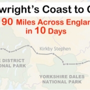
Only a few days to go now before myself and Mark Duerden attempt to walk the 190 mile Coast to Coast, created by the legendry Alfred Wainwright, in just 10 days. That’s a whopping average of 19 miles per day. Thankfully we get to stay in a hotel/pub each night to recover, or drink away the pain, and also get to see some of the most amazing countryside this country has to offer. We started this challenge purely as a personal one but with Pendleside Hospice being my favourite charity and run by some incredibly hard-working people, it wasn’t that hard to make the decision to raise some funds for them along the way.

I am hoping to be able to blog the journey each evening to let you all know how we are doing. I will post to Facebook and twitter regularly and you can also subscribe to this blog by entering your email address in the box at the bottom right of this page. This will ensure you get every post that is written here so you are right up to date with our progress. Im no literary genius but I will attempt to make it interesting and give you an insight into our amazing journey.

So if you feel like we are doing something good and you enjoy our journey then please please please spare a little of your hard-earned money and sponsor us. Every pound makes a huge difference to the hospice and ultimately the patients who rely on the amazing work the staff do for them.

http://www.justgiving.com/gr4ph

C2C

The C2C challenge has gone mobile

Ive now managed to get the site optimised for viewing on mobile devices. So now theres no excuse for following our progress no matter where you are. Just type in the blog address and the magic of the internet will work out what device you have and render it accordingly. http://graden.org.uk/c2c

Please sponsor us on our epic challenge either at:

Our secure Just Giving page http://www.justgiving.com/gr4ph

Or by texting a donation. Just simply send a text to 70070 with the code GDPH65 and the amount you wish to sponsor from the following choices £1 £2 £3 £4 £5 or £10.


Coast to Coast can be tracked LIVE!!

We have been testing our live tracking and it now seems to be working. Basically Mark has a Garmin GPS watch that can connect to an app on his iPhone. The watch sends location info at regular intervals to the app and this in turn posts it to a live link whenever we have an internet connection. So each day we will start the session going and post the link on all the social media sites, this blog and the Pendleside Hospice web site. All you have to do is click the link and it will show you a map in your web browser with our location and our progress so far that day. At the top it shows the distance walked  and time taken and at the bottom in the blue bar you can view various graphs of the progress.

With the walk going through some remote areas the live feed will be intermittent but once an internet connection is established the route and location will be brought up to date. Don’t you just love technology 🙂

Please sponsor us on our epic challenge either at:

Our secure Just Giving page http://www.justgiving.com/gr4ph

Or by texting a donation. Just simply send a text to 70070 with the code GDPH65 and the amount you wish to sponsor from the following choices £1 £2 £3 £4 £5 or£10.

C2C Live Tracker

Fundraising reaches £1000

Today my Pendleside Hospice fundraising total hit a whopping £1000. Just what we needed to get us on our way tomorrow 🙂

The total is a combination of my 13in13 challenge from last year and the Coast to Coast which we start tomorrow. Please don’t stop there though, the hospice always needs our donations and help to keep running. So its on to the next thousand now with my ultimate aim to reach £10,000 one day. @PendlesideHosp @PendleNews

Please sponsor us on our epic challenge either at:

Our secure Just Giving page http://www.justgiving.com/gr4ph

Or by texting a donation. Just simply send a text to 70070 with the code GDPH65and the amount you wish to sponsor from the following choices £1 £2 £3 £4 £5 or£10.

Here We Go

9:41 am at St Bees and we are off 🙂

20140525-094333-35013118.jpg

20140525-094332-35012745.jpg

20140525-094333-35013492.jpg

Day 1 – C2C Walk

We’ll here it is at last. After months of planning we are now here and on our way. The day started with an alarm call at 4am and by 5 I had picked up Mark and we were on the road to Richmond. We arrived at around 7am with dark skies looming and the minibus driver warned us of heavy rain from his trips over the last week. The forecast was for heavy rain showers so we packed the rucksacks with plenty of waterproof clothing. The minibus transported us on a 2 hour journey to St Bees before taking our luggage to the first hotel. So suddenly there we were, stood on the sea front with 190 miles ahead of us but amazingly the weather forecasters had got it totally wrong. Gorgeous blue skies greeted us as we made our way down to the waters edge, posed for a few photos, collected a pebble and dipped our boots in the water. Then we were off.
The route starts gently with a nice undulating stroll along the coastal path and in the glorious sunshine from St Bees lighthouse we were treat to good views of Southern Scotland and the Isle of Man. After 4 miles the route turns to the east and we then have the sea behind us. The day is a fairly steady walk and we managed to get a good pace going. Around 7 miles and another photo opportunity with the statue of a walker pointing the way. From their we just went through a lot of farmland to Cleator.
Then came a shock. We knew there was a hill but just hadn’t realised how hard and steep it would be. Nearly 2 miles of vertical ascent up a grassy path but to be honest, the views at the top were stunning. Looking back we could see our full days walk all the way back to the Irish Sea and forward was the stunning forest of ennerdale. A sharp decent with just a large style (which Mark fell off lol) and then a steady walk to ennerdale bridge and the day was over.
We really couldn’t complain at the weather and the walk felt fairly easy. Mark has a few minor problems with his toes and my Achilles is hurting a bit but we feel really good. The Stork Hotel where we are staying is very nice and the landlord is a top bloke. We had a cracking lasagne and 5 pints of alcoholic beverages so need to work hard tomorrow.

Today’s full route: Day One

20140525-230447.jpg

20140525-230629.jpg

20140525-230657.jpg

20140525-230706.jpg

20140525-230731.jpg

20140525-230745.jpg

20140525-231231.jpg

20140525-232025.jpg

20140525-232031.jpg

20140525-232037.jpg

20140525-232050.jpg

20140525-232103.jpg

20140525-232108.jpg

20140525-232115.jpg

20140525-232120.jpg

20140525-232127.jpg

20140525-232226.jpg

Day 2 – C2C Walk

Another day today that threatened bad weather but turned out fantastic. During the night I was woken by what sounded like stones hitting the windows. It was in fact rain in a proper downpour. When we woke at 7am it was very gloomy but had at least stopped raining. We had a really good full English breakfast with the best sausages I’ve tasted in ages, although Mark wasn’t keen.
The landlord called us out to the minibus for the short trip down to our starting point at Ennerdale Bridge along with some other coast to coasters. One was a tall long haired guy who had found a 6ft branch and was carrying it as a walking stIck. Mark nicknamed him Gandolph and we fully expected him to give the bus a miss and just appear at the start point but I guess he was saving his powers for something better later.
The walk started by heading down a lane then along a forest track to the edge of Ennerdale Water. The weather was brightening all the time and was very warm now meaning the jacket was off and it was shorts and a t-shirt all the way. The views by the lake were breathtaking and I’ll definitely be back again to walk here. The pictures below just don’t do it justice.
The next 9 miles to Black Sail youth hostel were fast but also quiet as we just took in the amazing scenery. We stopped for lunch at the bottom of a path that lead up to the summit of Haystacks. So I offered mark a diversion. I’ve already scaled Hay Stacks but thought it would be real treat to include this in our journey. He agreed and so off up the mountain we went. What an inspired decision. A steep climb followed by some great scrambling and then there we were at the summit of Wainwrights favourite fell. We posed for a few pics then head off in the direction of the tarn where Wainwrights ashes were sprinkled for his final resting place. Quite fitting to come here on what is his Coast to Coast route. We dropped from there to Honistor slate mine, taking in stunning views of Buttermere on the way. From Honistor it was just a few miles along the road to our accommodation at Seatoller Farm. And that was a pleasant surprise with really nice room and lovely people. Unfortunately there is no phone signal, no internet and no evening meals ( we did know this in advance) so we jumped on a bus and went to Keswick. A few beers and a really tasty freshly made burger meal and then it’s off back for a good nights sleep. Tomorrow is the hardest day of the whole route with some serious ascents to negotiate.
So far though it’s going well with 30 miles done and only 160 to go. The weather gods are on our side for now and we have no injuries or aches and pains for that matter.
Long May it continue 🙂

Full route from today: Day Two

20140526-181518.jpg

20140526-181535.jpg

20140526-181540.jpg

20140526-181604.jpg

20140526-181621.jpg

20140526-181629.jpg

20140526-181648.jpg

20140526-181654.jpg

20140526-181705.jpg

20140526-181659.jpg

20140526-181750.jpg

20140526-181754.jpg

20140526-181802.jpg

20140526-181813.jpg

Day 3 – C2C Walk

We knew today was the toughest of the whole route but never imagined just how tough. We started with a few steady miles through Borrowdale valley before starting a long slow climb up to Lining Crag and then to Greenup Edge. This really is a tough climb but when we turned to look at our path behind us it was breathtaking and worth every step. The views looked all the way back through Borrowdale to our starting point for the day. The next section turned out to be a bit of a farce. I’d looked at my gps and it showed us climbing a bit further. So on we went up this hill through some of the boggiest land we could imagine. Marks feet were soaked as he dint have waterproof shoes on. Over half way up and I suddenly noticed the others walking were behind us taking a different route. A quick check of the GPS and yep we had gone the wrong way. About 1 mile wrong. So off we went back through the same bog and getting wetter.
Once back on track we set off back down hill and towards Grasmere. After a lunch stop we decided to take the high route and took in 3 more wainwright fells, Calf Crag, Gibson Knott and Helm Crag. From there it was a steep downhill then the worst part of the journey so far.
After crossing the road that leads to Grasmere we set off up Great Tongue, a valley that sits between Seat Sandal and Fairfield. How hard was this, just relentless uphill grassy path for 3 miles. The only highlight of this climb was a black sheep with white eyes. It looked like it was wearing a mask and was gonna hold us up. By the top we were knackered but also pleased to see Grisedale tarn. This is my favourite place in the whole of the lakes and we took 10 mins out to have a food and drink stop. We then set off down the next valley to Patterdale. On the way down we met up with a guy who started at the same time as us. Chatting with him made the last 4 miles go quick. The accommodation isn’t the best but it will do. However, we went out to the Old Water View pub which is the one featured in the TV series about the coast to Coast. It’s where Wainwright stayed every year since 1931 when walking up here and doing his drawings. The landlord told us some stories of his stays and also enlightened us on his own daughter who at 9 years old has already done the coast to Coast 3 times. Amazingly his mother is also the oldest person to do it at 80 and was actually at Richmond today on the route again.
So the hardest day is done and we are now 48 miles in to the challenge and we should now be able to start doing some easier high mileage days.

Day 3 Route: route

20140527-225948-82788670.jpg

20140527-225949-82789012.jpg

20140527-225947-82787347.jpg

20140527-225947-82787704.jpg

20140527-225946-82786606.jpg

20140527-225949-82789500.jpg

20140527-225946-82786203.jpg

20140527-225946-82786996.jpg

20140527-225950-82790039.jpg

20140527-230827-83307904.jpg

20140527-230828-83308711.jpg

20140527-230827-83307286.jpg

20140527-230828-83308989.jpg

20140527-230828-83308071.jpg

20140527-230826-83306950.jpg

20140527-230830-83310307.jpg

20140527-230830-83310015.jpg

20140527-230830-83310832.jpg

20140527-230831-83311447.jpg

Day 4 – C2C Walk

The alarm woke us at 7am and after a bacon and sausage butties we were off down the road. Very quickly we were climbing up a tough hill but at the top we were rewarded with a view of the stunning Angle Tarn. It’s a small lake but has 2 Islands and a cove and as Mark said “it looks like something off Lord of the Rings”. At that point the mist rolled in and by the time we reached the summit of The Knott it was drizzling enough to put the waterproofs on over the shorts. Another mile up and we reached the highest point of the whole coast to Coast route, Kidsty Pike. And this time we were rewarded with……….a view of white cloud. But the achievement was the main thing. A long decent came next down to the shore of Haweswater and although it was still drizzling the views were back. Haweswater is a man made lake and was the idea of Manchester water company in the 1930’s . They needed a supply of drinking water to provide the ever growing Manchester area and so it was decided to move the residents out of a village called Mardale over to Shap and then build a dam and flood the valley. The village still remains underneath the water and when there is a hot summer the water level drops to reveal the tops of the church and some buildings. This blog is now giving history lessons lol.
The next 5 mils are a steady walk along the shore of Haweswater up to the village of Burnbanks which was built to house the workers building the dam. A brief stop here which included meeting up with a bloke called Thomas who had started at the same time as us and who we’d met at various points each day. We decided to walk the last 4 miles to Shap together and then set off through bluebell woods, buttercup filled fields and then country lanes before arriving at the Kings Arms. The room here is the best we’ve had so far and the meal was stunning and only £7. A few games of pool (for the record I beat mark 2-1)

20140529-083847-31127240.jpg

20140529-083849-31129624.jpg

20140529-083847-31127956.jpg

20140529-083851-31131385.jpg

20140529-083850-31130433.jpg

20140529-083847-31127579.jpg

20140529-083848-31128644.jpg

20140529-083850-31130031.jpg

20140529-083846-31126921.jpg

20140529-083848-31128283.jpg

20140529-083850-31130851.jpg

20140529-083846-31126587.jpg

20140529-083849-31129190.jpg

20140529-084219-31339204.jpg

20140529-084219-31339864.jpg

20140529-084218-31338217.jpg

20140529-084218-31338555.jpg

20140529-084219-31339522.jpg

20140529-084218-31338890.jpg

20140529-171821-62301963.jpg

Day 5 – C2C Walk

Another early alarm call at 6-45 and down for another full English. It’s just got to be done on this walk, it’s the rules 🙂
After that it was off on what most people call the best day of the challenge. It’s a long day at 21 miles but it’s steady away over lots of rolling farmland. Our first point of interest was at 1 mile when we walked over a bridge that spans the M6 motorway. Two things to note here, firstly when you stand on the bridge looking south, everything to your right is the lakes which are now behind you and to he right is the Yorkshire dales which are your focus for the next few days. It’s the point where you finally leave the mountains behind and marks a change in landscape and terrain. The second is that there was a great big mast at the side of the bridge and that meant super fast internet to upload yesterday’s blog post and a chance to text people back home. We were like kids in a sweet shop as we browsed the internet text for our lives.
So a slow first mile but then we really got a good pace going. After 2 miles we met a young couple carrying full camping gear. We ended up chatting and walking most of the day with them. It turned out the couple were wild camping along the way, carrying huge backpacks and that Ross had proposed to Laura as part of the challenge on top of Hay Stacks in the lakes. I think he just wanted to give her the ring to shed some weight from his pack 😉 They really were great company and the conversation helped the miles drift by.
The day was different to what we had walked so far. It was still special but not quite as dramatic as the stunning lakes and mountains. We rolled through field after field walking on mostly grassy paths taking in views of the Howgills, the trough of bowland, sunbiggin tarn and as we approached Kirkby Stephen we had the treat of a WWII bomber flying at eye level in the valley ahead of us.
Yet again the weather was kind with a stiff breeze and cloudy skies but dry. We just can’t believe our luck with the weather as the forecast at the start was for rain every day. It’s actually only rained yesterday and that was only drizzle.
We had drifted away from Ross and Laura but with 2 miles to go we stopped for a coffee break and they caught us up so we finished the day with them. We arranged to meet for an meal at our hotel and had a great evening with some very good food and had a real good laugh. We were joined by another young man, who was born in Argentina, grew up in Italy and now lived in Denmark. He was also doing the walk but he couldn’t read maps very well and didn’t have any waterproof clothing. We had seen him once before on day 3 stood on top of the Knott lost in the rain. I still don’t know just how he is gonna get to the end of this but somehow I suppose he will.
As we are now pushing on with some big mileage days we sadly had to say goodbye to Ross and Laura. I’ll be honest id love to have walked the rest of the walk with these two and we will really miss them. If you are both reading this then I wish you all the best with your wedding and the future. We may not get chance to meet again but you’ll always be thought of when I reminisce over this challenge.
So we now have 5 days under our belt and tomorrow we will walk 25 miles, hit the half way point and then hit the 100 mile mark. A superb achievement and this really is the best experience of my life so far. Can’t wait for the next 5 days.

20140529-213208-77528717.jpg

20140529-213209-77529034.jpg

20140529-213209-77529323.jpg

20140529-213210-77530283.jpg

20140529-213209-77529614.jpg

20140529-213209-77529951.jpg

20140529-213344-77624268.jpg

20140529-213344-77624935.jpg

20140529-213343-77623957.jpg

20140529-213344-77624603.jpg

20140529-213346-77626631.jpg

20140529-213345-77625285.jpg

20140529-213345-77625732.jpg

20140529-213824-77904821.jpg

20140529-213824-77904541.jpg

20140529-213823-77903956.jpg

20140529-213824-77904249.jpg

20140529-213823-77903647.jpg

20140529-214053-78053127.jpg

20140529-214052-78052778.jpg

20140529-214053-78053480.jpg

20140529-215858-79138819.jpg